
It is hard to believe that it is the 8th anniversary of the devastating natural disaster, Hurricane Katrina. She began on August 23, 2005 as the 12th tropical depression of the season forming over the Bahamas and in ten days she became
- the costliest natural disaster in the history of the United States. (estimated $81 billion)
- one of the five deadliest in United States History.
- the sixth strongest overall of recorded Atlantic hurricanes.
- deadliest U.S. hurricane since the 1928 Okeechobee hurricane.
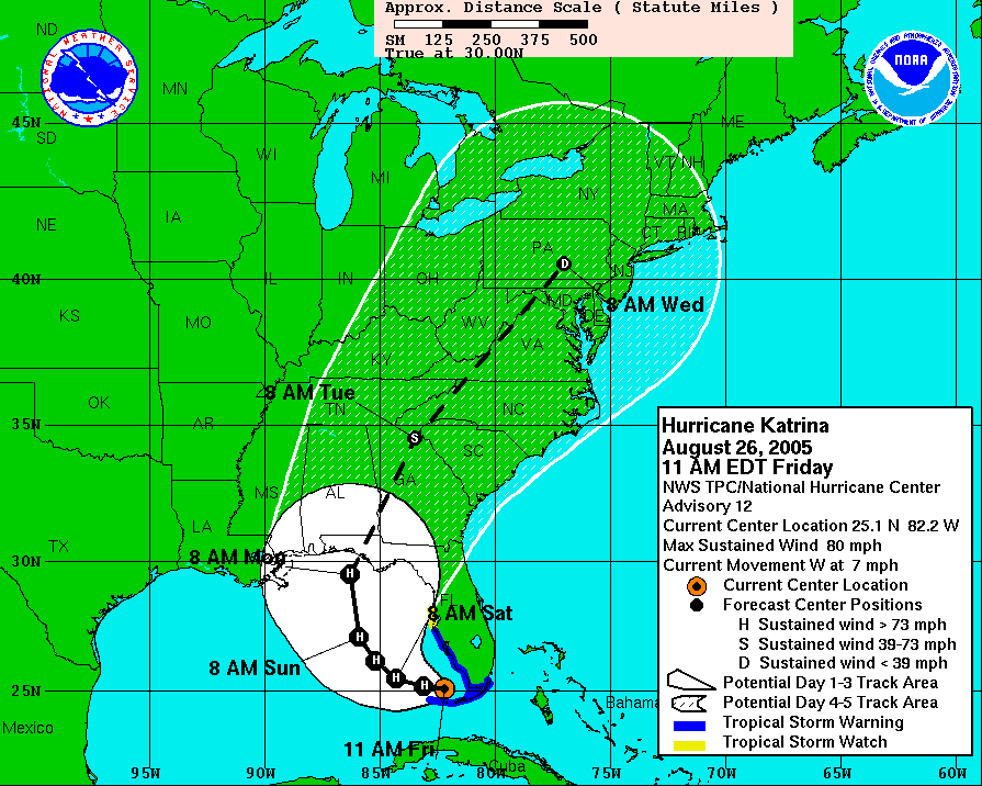
HURRICANE KATRINA’S TEN DAY TIMELINE
In this part 1 of 2, I will cover the beginning on August 23, 2005 up through August 28, 2005
Tuesday, August 23, 2005
5 p.m.: The National Hurricane Center in Miami, Florida, issues its first advisory about the tropical system that will become Hurricane Katrina. The advisory notes that the season’s 12th tropical depression has formed over the Bahamas. The weather system is about 350 miles (560 kilometers) east of Miami.

Wednesday, August 24, 2005
11 a.m.: The storm has strengthened, become more organized, and been given a name. It is now tropical storm Katrina, the 11th named storm of 2005, about 230 miles (370 kilometers) east of Miami. Its strongest winds are blowing at about 40 miles an hour (65 kilometers an hour).

Thursday, August 25, 2005
5 p.m.: Katrina has continued to strengthen and is now a hurricane. Its strongest winds are about 75 miles an hour (120 kilometers an hour), making it a Category One hurricane. The storm is about 15 miles (25 kilometers) east of Fort Lauderdale, Florida, and about to make landfall.

A Fort Lauderdale parking lot is blasted by blowing sand and rain as Hurricane Katrina makes landfall along the southeast coast of Florida on August 25, 2005.
7 p.m.: The eye of Hurricane Katrina comes ashore between North Miami Beach and Hallandale Beach on Florida’s southeastern coast. The storm’s top winds are 80 miles an hour (130 kilometers an hour). Falling trees kill two people.

August 25, 2005: Katrina makes Landfall in Florida
Katrina was a (wimpy) category 1 hurricane, with sustained wind speeds of 75 mph and a low pressure of 985 mBar, when it made landfall in Florida, 3.5 days prior to the landfall in Louisiana. Nevertheless, David’s photo captured the awesome power even a weak hurricane has. David “rode out the storm” at the beach with a few TV reporters.
(David Nourani, ERTH15 student, 2005)
Friday, August 26, 2005
1 a.m.: Katrina weakens and is reclassified as a tropical storm. Its center is about 45 miles (70 kilometers) northwest of Key Largo, Florida. Its strongest winds are about 70 miles an hour (115 kilometers an hour).
3 a.m.: The storm’s center has emerged from the Florida peninsula and starts strengthening almost immediately as it touches the warm waters of the Gulf of Mexico.
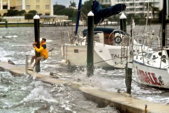
Todd Goldsberry clings to a piling while making his way back to shore from his sailboat “Talisman” in the Intracoastal Waterway at the Palm Beach Yacht Club Thursday in West Palm Beach, Fla.
5 a.m.: Katrina reintensifies into a hurricane. Its strongest winds are about 75 miles an hour (120 kilometers an hour), and its eye is about 70 miles (115 kilometers) northwest of Key Largo. Keys residents are surprised by Katrina’s strength as it passes offshore.
“We went to bed last night expecting some possible rain and woke up this morning to learn that Katrina was 75 miles [120 kilometers] north of Marathon [Florida],” says Dan Gallagher, resident of Grassy Key. “A lot of the live-aboards [people living on houseboats] in Boot Key Harbor were surprised to find their boats in new spots.”
11:30 a.m.: The National Hurricane Center reports that the hurricane is “rapidly strengthening” as it crosses the Gulf of Mexico’s very warm waters. In only a few hours, the storm’s strongest winds have increased to about a hundred miles an hour (160 kilometers an hour).
During the day: Governors Kathleen Blanco of Louisiana and Haley Barbour of Mississippi declare states of emergency in their respective states.
1 p.m.: The National Hurricane Center predicts that Katrina will become a major hurricane by the time it reaches the central Gulf of Mexico. The eye of the storm is now about 460 miles (740 kilometers) southeast of the mouth of the Mississippi River in Louisiana.

Saturday, August 27, 2005
5 a.m.: Katrina’s strongest winds have reached 115 miles an hour (185 kilometers an hour), making it a Category Three hurricane.
During the day: Hurricane-hunter aircraft fly into Hurricane Katrina to measure wind speed, barometric pressure, ocean surface temperature, and other data.
“It was certainly very strong and also was very large,” Chris Landsea said later. Landsea, a meteorologist with the National Oceanic and Atmospheric Administration, was aboard a flight into Hurricane Katrina. “When we were flying into it Saturday, its circulation covered the entire Gulf of Mexico.”

NOAA hurricane hunter aircraft made ten flights into and around the eye of Hurricane Katrina.

Sunday, August 28, 2005
2 a.m.: Hurricane Katrina’s winds have increased to 145 miles an hour (235 kilometers an hour), making it a Category Four storm. The eye of the storm is about 310 miles (500 kilometers) south of the mouth of the Mississippi River.
9:30 a.m.: New Orleans Mayor Ray Nagin issues a mandatory evacuation order. Tens of thousands of New Orleans residents begin streaming out of the city.
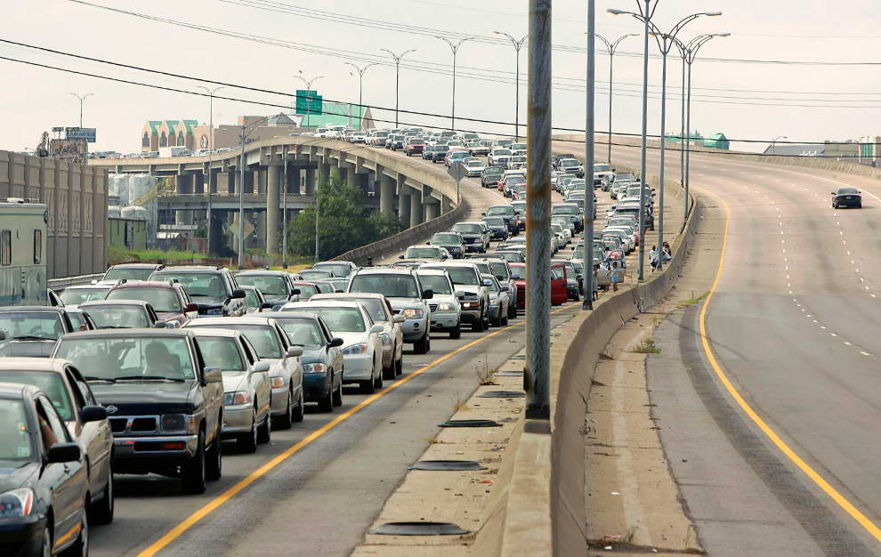
Cars carrying residents leave downtown New Orleans ahead of Hurricane Katrina in this August 28, 2005 file photo. (REUTERS/Rick Wilking)

People evacuating from Louisiana and Mississippi travel along eastbound Interstate 10 in Biloxi, Miss. on Aug. 28, 2005. Katrina showed Mobile planners that the city’s evacuation plan needed to be rethought.
“We’re facing the storm most of us have feared,” Nagin said. “This is going to be an unprecedented event.”

11 a.m.: Hurricane Katrina has mushroomed into one of the most powerful hurricanes ever to form in the Atlantic. The storm’s strongest winds are blowing at about 175 miles an hour (280 kilometers an hour), making it a Category Five storm. The center of the storm is about 225 miles (360 kilometers) from the mouth of the Mississippi River.
5 p.m.: The National Hurricane Center describes Katrina as a “potentially catastrophic” hurricane.
“Some levees in the greater New Orleans area could be overtopped,” the center warns. “Significant storm surge flooding will occur elsewhere along the central and northeastern Gulf of Mexico coast.”
9:15 p.m.: A. J. Holloway, mayor of Biloxi, Mississippi, says his city is “getting some rain, a little wind, and some lightning and thunder” from Hurricane Katrina.
Holloway survived Hurricane Camille in August 1969, and he’s worried that this hurricane will be as bad or worse than that catastrophic storm. He’s also worried that many new residents of Biloxi have no idea what they may soon be facing.
“There’s a lot of new people who moved into Biloxi with the advent of casino gambling who have never experienced a real hurricane, and they may be taking it lightly,” Holloway tells National Geographic News. “And even some of the people who were here during Camille are not worried. But just because your house stood up during Camille don’t mean it’ll stand up to this hurricane.”
Late Sunday night: Thousands of New Orleans residents who are unable to leave town or have chosen not to leave seek shelter in the Louisiana Superdome.

Residents in New Orleans, Louisiana leave the city with their belongings 28 August 2005 as Hurricane Katrina draws near.

A US Army soldier performs crowd control as New Orleans area residents, seeking refuge from Hurricane Katrina, arrive at the Superdome which has been set up as an emergency hurricane shelter, in New Orleans, Louisiana 28 August 2005. Hurricane Katrina, now a category 5 hurricane, packing winds of 280 kilometers (176 miles per hour), is expected to make landfall near New Orleans early 29 August 2005.
In the next part of this two part post, I will start with August 29, 2005 when Katrina makes landfall in Louisiana.
 – A Father’s Untold War Story") Check out my other blog
Check out my other blog I'M PUBLISHED
 I'm Published Again


I love your use of maps. I remember watching it on TV here in Australia. Unbelieveable !
LikeLike
It was devastating to watch on TV. We had a bad one on the east coast last year and luckily I live inland and only experienced power failure for 34 hours.
LikeLike
[…] is Part 2 of my two part blog post about this event in history. Click here to read Part […]
LikeLike